FULL TOUR
A Change of
Address - SITE SELECTION
The development of
Ottawa-Gatineau, as a capital expressive of national identity
and a source of national pride, is the responsibility of the
National Capital Commission (NCC). One of its key strategies,
has been to bring Gatineau (formerly Hull) into the capital in
more than just name, to enhance the image of the capital as the
symbolic centre of a nation of two official cultures.
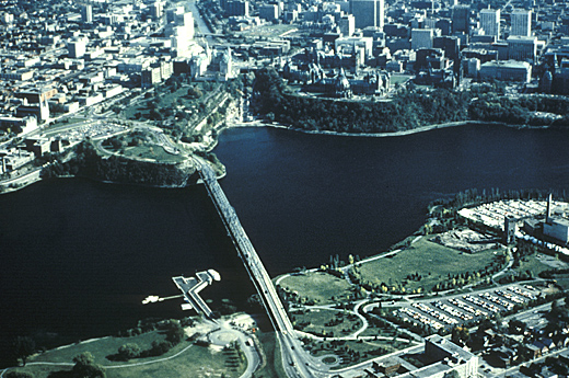
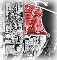
The core area of the capital. When this
photo was shot the future site of CMC (at bottom right) was
occupied by parkland and parking lot.
© National Capital Commission
|
Gatineau had been neglected while the southern bank of the
Ottawa River was undergoing rapid development; it had benefited
little from its nominal inclusion in the capital. Federal
building in Gatineau was the solution proposed; a mix of
cultural, administrative, commercial, and residential functions
would avoid concentration of land uses. In the 1970s large
buildings to serve the federal bureaucracy were erected in
Gatineau, but there remained the need to complement them with
cultural and public-oriented facilities.
A further tactic in helping to tie Ottawa and Gatineau together
was the development of a ceremonial route, circling the Core
Area of the capital and passing major national institutions. Key
sites along the proposed route were acquired by the NCC and
reserved for institutions that are essential building blocks in
establishing a strong chain of national symbols, such as the
Canadian Museum of Civilization. Plans for the Capital Core Area
were thus the context for the decision to build a new museum.
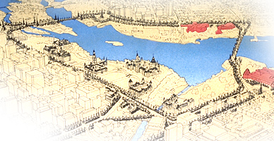
Confederation Boulevard is a ceremonial
route that ties together the Ottawa and Gatineau components of the
National Capital. Visitors who follow its path are introduced to
many of the major monuments - heritage, cultural, and
political - of city and nation. Its symbolic significance
makes it a prime target-area for the placement of new cultural
institutions such as CMC and the National Gallery of
Canada.
© Canadian Museum of Civilization, CD95-722-061
|
The first task of the New Accommodation project was the
selection of the best architect and the most suitable site. The
Canada Museums Construction Corporation commissioned a study of
possible locations. It assumed that an appropriate site would be
within the Capital Core Area, on publicly-owned land, linked to
the intended ceremonial route, and preferably visible from both
the Gatineau and Ottawa sides of the river. Five prominent sites
were compared; any would have been satisfactory to hold a museum
that was to be a symbol of national heritage, although in fact
it had largely been pre-determined where CMC would be placed.
All of the sites lay along the envisaged ceremonial route, and
most of them on the primary part of that route known as
Confederation Boulevard.
Of the five sites, only one lay on the Gatineau side of the
river: a former industrial site which the NCC had acquired from
E.B. Eddy Company in 1972 and converted into a mix of parkland
and parking. Parc Laurier was targeted as a prime site for a
national museum even before the comparative site analysis. Both
by the NCC, which desired a cultural institution in that part of
the capital to attract tourists across the river and to make
Gatineau seem more a part of the capital, and by the City of
Gatineau, whose development plan (1980) aimed at making Parc
Laurier an urban park with a transitional building form that
would link the downtown buildings to the riverfront.
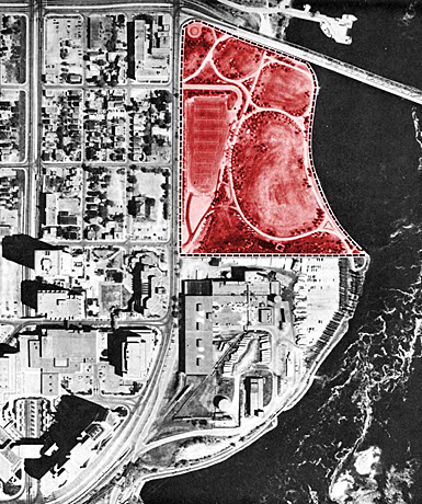
Parc Laurier was targeted as a prime site
for a national museum.
© National Capital Commission
|
|
It was a natural decision that, of the two national museums to
be built, one should be on the Ottawa side and one on the
Gatineau side. And since CMC had in the past attracted more
visitors than the National Gallery, it was considered the better
choice for the Gatineau site. When the museum site analysis
showed no reason to reject Parc Laurier, its fate was sealed.


|