
Research team
Research Division leadership
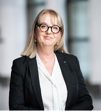
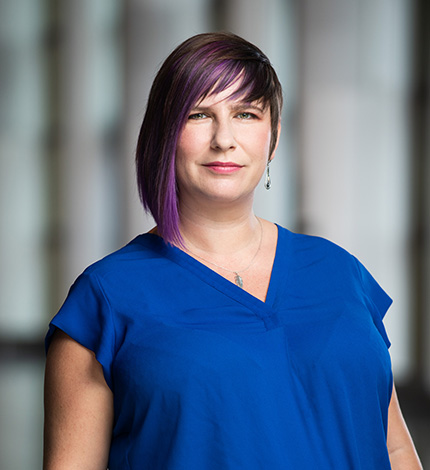
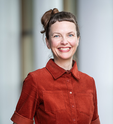
Bianca Gendreau
Senior Director, Research, and Chief Curator
Canadian Museum of History
Bianca Gendreau leads an interdisciplinary team of curators working on different approaches to research and enrichment of the national collection.
The Canadian History Research Centre is also part of the Research Division, and her team is responsible for access to the Museum’s library and collections.
Bianca Gendreau’s research interests focus on contemporary issues, including the functions of research, responsibilities towards collections, and the digital future in the context of museums.
She has an MA in History and an MA in Museology from the Université de Montréal.
-
Behind the Scenes… Early Holiday Cards
November 29, 2021 | Blog
-
Words of Love: Valentines of the Victorian Era
February 13, 2015 | Blog
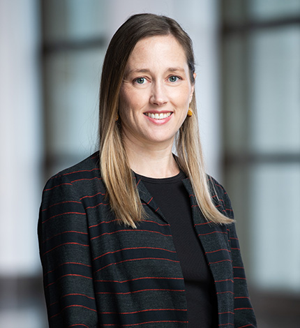
Laura Sanchini
Manager, History and Cultural Expression
Canadian Museum of History
Laura Sanchini is a folklorist, oral historian, and craft scholar who has been with the Museum since 2015 — first as Curator of Craft, Design and Popular Culture, and more recently as Manager, History and Cultural Expression.
Sanchini’s research interests include oral history methodologies, intangible cultural heritage, and vernacular aesthetics in contemporary craft traditions. She currently leads the Museum’s major oral history initiative, Shaping Canada, which seeks to document the experiences of influential people in Canada. She is past-President of the Folklore Studies Association of Canada and a member of the Board of Directors for the Italian-Canadian Archives Project.
In addition, Sanchini sits on the editorial boards of Ornamentum magazine and the Mercury Series, and has been published in Digest: A Journal of Foodways and Culture, Ethnologies, and Material Culture Review. Prior to joining the Museum, she worked as an oral historian at the Canadian Museum of Immigration at Pier 21, and as a lecturer and archives assistant at Memorial University of Newfoundland.
Sanchini has a BA (First Class Honours) in History and World Religions from McGill University, as well as an MA and a PhD in Folklore from Memorial University of Newfoundland.
-
“Desserts” is “Stressed” Backwards: COVID-19 and Pandemic Foodways in Canada
May 4, 2022 | Blog
-
Carving a Lifetime: The Miniature Village of Saint-Jean-Port-Joli
October 14, 2015 | Blog
Early Canada & Indigenous Peoples and Communities
Early Canada
Understanding the territory that is now Canada through the stewardship of archaeological material.
Matthew Betts
Curator, Eastern Archaeology
Canadian Museum of History
Matthew Betts has been Curator, Eastern Archaeology, since 2007. His current research focuses on maritime hunter-fisher-gatherers, and their profound relationships with animals and ecosystems.
Between 2008 and 2020, he collaborated with Acadia First Nation to explore Mi’kmaw culture history, resulting in the monograph Place-Making in the Pretty Harbour (2019). In 2021, with M. Gabriel Hrynick, he also published the first comprehensive evaluation of the region’s archaeological history in The Archaeology of the Atlantic Northeast.
Betts was one of the lead curators for the Canadian History Hall. He has twice won the Canadian Archaeological Association’s Public Communications Award, and is the first Chair of their Climate Change Committee, which developed the CAA Statement on Climate Change and Archaeology in 2022. He is a fellow of the Royal Canadian Geographical Society and an adjunct professor in the Department of Anthropology at the University of New Brunswick. Betts holds an MSc and a PhD from the University of Toronto.
-
Archaeology Without Borders: Contact-Era Archaeology in Maine
August 3, 2022 | Blog
-
Repatriation Project Reveals Remarkable Story – Part 2: Telling the Story
August 30, 2017 | Blog
-
Repatriation Project Reveals Remarkable Story
August 24, 2017 | Blog
Pierre Desrosiers
Curator, Central Archaeology
Canadian Museum of History
Pierre Desrosiers joined the Museum in 2019 following extensive experience working with Indigenous Peoples in northern Quebec. As Curator of Central Archaeology, he oversees collections related to Ontario and Quebec, and is interested in the intergenerational and intercultural sharing of technologies — particularly the ingenuity of material knowledge and skills.
Desrosiers views community archaeology as a way of understanding the past, while highlighting traditional knowledge and providing informal education. His work promotes the inclusion of local communities at all stages of a multidisciplinary research project, incorporating the earth sciences, an analysis of technologies, and the history of these types of investigations.
Desrosiers was trained in Anthropology at the Université de Montréal, and has an M.A. from the Université de Nanterre and a Ph.D. from the Université Panthéon-Sorbonne in Paris. He has edited three books, including The Emergence of Pressure Blade Making (2012) and Ramah Chert: A Lithic Odyssey (2017). The latter was produced in relation to the official recognition of kitjigattalik — Ramah Chert Quarries as a National Historic Site.
-
Conservation Science: The Hidden World Behind Exhibiting Ancient Objects
January 3, 2025 | Blog
-
A long-awaited synthesis: The Far Northeast
November 29, 2023 | Blog
-
A Book in the Service of a Cause: The Role of Canadian Women During the Two World Wars
November 10, 2022 | Blog
-
Reflections on 1968: An Electrifying Year in Canada
April 26, 2022 | Blog
-
Port of Entry: Immigration Stories From Pier 21
October 6, 2020 | Blog
-
When Cree and Inuit Transformed Modern Canada
November 27, 2019 | Blog
-
Daniel Weetaluktuk: A Community Archaeology Pioneer
November 7, 2019 | Blog
Karen Ryan is responsible for archaeology and history collections at the Museum relating to Canada’s northern regions. She has conducted archaeological fieldwork throughout much of Inuit Nunangat, as well as in Newfoundland and Labrador, at sites once occupied by PalaeoInuit and Inuit groups. She currently works in Nunavik where, in collaboration with local community organizations, she is exploring the social, ideological and economic lives of the Dorset PalaeoInuit (the Tuniit of Inuit oral tradition).
Ryan curated the award-winning exhibition Death in the Ice: The Mystery of the Franklin Expedition, which was presented in the United Kingdom, Canada, and the United States between 2017 and 2019. She is also the curator of The Ones We Met – Inuit Traditional Knowledge and the Franklin Expedition, which is currently travelling across Canada.
A Fellow of the Royal Canadian Geographical Society, Ryan has a PhD from the University of Toronto.
-
Qajartalik 2022 – Collaborative Community-Based Archaeological Fieldwork in Nunavik
September 6, 2022 | Blog
-
Inuit Knowledge and the Franklin Expedition Exhibition
October 11, 2017 | Blog
-
Remembering the Franklin Expedition — The Lieutenant Fairholme Collection
June 15, 2017 | Blog
Gabriel Yanicki
Curator, Western Archaeology
Canadian Museum of History
Gabriel Yanicki joined the Museum in 2018. He is responsible for researching and developing archaeological collections at the Museum reflecting the cultural history of the First Peoples of the Plains, Interior Plateau, Northwest Coast, and Western Subarctic.
Yanicki’s research explores how kinship, social distance, and identity are reflected in archaeological materials and styles, and how indicators of the movement of ideas, individuals, and groups can reveal intercultural contact and sociodemographic change.
Yanicki has an MA and a PhD in Anthropology from the University of Alberta. His work has covered such topics as the archaeology of traditional games, Dene migration and the emergence of proto-Apachean social identities, and the first peopling of the Ice-Free Corridor. He is the author of Old Man’s Playing Ground: Gaming and Trade on the Plains/Plateau Frontier (2014), a Mercury Series volume published by the Canadian Museum of History and the University of Ottawa Press.
Janet Young
Curator, Biological Anthropology
Canadian Museum of History
Janet Young specializes in the study of human skeletal remains, and has been working at the Canadian Museum of History since 1994.
Young’s research interests include biomechanical and pathological changes in the human skeleton, as they relate to the activity patterns and general health of past and present populations. Her publications and presentations have covered a wide range of topics, including repatriation, forensics and historical bioarchaeology. Her current work deals with a historical cemetery population from the Ottawa area.
Young has an Honours BA in Archaeology and Ancient History from the University of Ottawa; an MSc in Human Osteology, Palaeopathology and Funerary Archaeology from the University of Bradford, England; and a PhD in Population Health from the University of Ottawa.
-
Bone Detective – the “Iron Man” of the Barrack Hill Cemetery: a Life in Contrast
October 6, 2023 | Blog
-
Bone Detective – a Box of Secrets
October 6, 2023 | Blog
-
Bone Detective – The Maiden: Could She Have Been a “Mad Hatter”?
October 6, 2023 | Blog
-
Bone Detective – “The Violated”: Not Buried Alone
October 6, 2023 | Blog
-
Bone Detective – Mysteries of Those Found Beneath Downtown Ottawa: Series Introduction
October 6, 2023 | Blog
-
What DNA Analysis Can Tell us About Bytown Settlers
August 26, 2022 | Blog
-
Repatriation Project Reveals Remarkable Story – Part 2: Telling the Story
August 30, 2017 | Blog
-
Repatriation Project Reveals Remarkable Story
August 24, 2017 | Blog
Indigenous Peoples and Communities
Working toward shared stewardship and collaborative research with Indigenous Peoples and communities.
Sarah Barnes joined the Museum in 2023 as Curator, Sport and Leisure. She is a former Assistant Professor of Experiential Studies in Community and Sport at Cape Breton University, and holds an MA and a PhD from the School of Kinesiology and Health Studies at Queen’s University.
In addition, she has completed Postdoctoral Fellowships in the Sports, Society, and Technology program in the School of History and Sociology at the Georgia Institute of Technology and in the School of Kinesiology and Health Science at York University.
Barnes has extensive experience in research, teaching and publications, along with expertise in the history of athlete welfare and social issues in sport. She is a former varsity basketball player and coach, who worked for five summers as a team manager with the Canadian Women’s National Basketball Program.
-
Comparing Olympic parkas: Thinking historically about winter gear
March 28, 2025 | Blog
-
Olympic Torches: Sparking Conversations About Sport and Society
August 7, 2024 | Blog
Salina Kemp
Curator, Indigenous Histories and Contemporary Cultures, East
Canadian Museum of History
Salina Kemp joined the Museum in 2022 following several years as a researcher and volunteer with Indigenous organizations. Kemp was also a guest curator and consultant for the Maritime Museum of the Atlantic, working with both tangible and intangible collections, while demonstrating how unique the Mi’kmaw continue to be.
Kemp’s curatorial responsibilities include the Eastern Woodlands, Northeastern Atlantic, and the Eastern Sub-Arctic Ethnology collections. Research interests include Indigenous food security and the reclamation of sovereignty, including the integration of traditional knowledge, the repatriation of culturally significant materials, and the importance of ongoing informed consent in Indigenous research.
Kemp has a BA in Political Science, Philosophy, and Atlantic Canadian Studies, as well as an MA in Atlantic Canadian Studies, from Saint Mary’s University. Her studies include Mi’kmaw resistance to policies and legislation with a negative impact on Indigenous rights in Atlantic Canada.
Kaitlin McCormick
Curator, Indigenous Histories and Contemporary Cultures, West
Canadian Museum of History
Kaitlin McCormick began working at the Museum in 2007, supporting the research, documentation and repatriation of Indigenous collections from British Columbia. This experience inspired her graduate and postdoctoral research, which focused on how Indigenous artists documented their experiences on the Northwest Coast during the 1800s and 1900s, as well as the history of ethnographic collecting in that region.
In 2019, McCormick joined the Museum as Curator, with responsibilities that include stewarding collections from the Western Subarctic, Northwest Coast, and Plateau. As a curator, she continues to support the Museum’s repatriation priorities, and is currently developing a major research and exhibition project involving a critical revisitation of the 1927 “Exhibition of Canadian West Coast Art: Native and Modern,” which will be undertaken in collaboration with colleagues and experts on the Northwest Coast.
McCormick holds an MA in Art History from Carleton University and a PhD in Canadian Studies from the University of Edinburgh. She also completed postdoctoral training at Brown University and Yale University.
She is keen on providing greater access to collections, and welcomes requests for access from community members, artists and experts across Western Canada.
Chloé Ouellet-Riendeau
Assistant Curator, Sport History
Canadian Museum of History
Chloé Ouellet-Riendeau joined the Museum in 2023 as Assistant Curator, Sport History. Her work involves documenting and promoting the history of Canadian sport, with a specific focus on how the history of a sport reflects the social and political movements of its time.
Ouellet-Riendeau has published articles for the general public on the regional history of Quebec’s Eastern Townships, particularly in relation to legal history, commercial history, and sports history. Between 2016 and 2018, she took workshops with the Canadian Conservation Institute on the reorganization of collections storage, later becoming a trainer for RE-ORG Canada.
Ouellet-Riendeau has both a BA and an MA in History from the Université de Sherbrooke, as well as a diploma in Archival Practices from Université Laval. She is primarily interested in the agency of individual people and groups, and the roles they have played in the urbanization and industrialization of Quebec. Her MA research involved an exploration of the role of the Simard family in the development of the town of Sorel, Quebec, in the early 20th century.
-
Accessibility and Inclusiveness: Evolving Resources for People Impacted by Blindness
December 13, 2023 | Blog
Katie Pollock
Curator, Indigenous Histories and Contemporary Cultures, Central
Canadian Museum of History
Katie Pollock joined the Museum in 2017. Born, raised and rooted in Treaty 2 Territory (rural southwestern Manitoba), she serves as a steward of tangible and intangible heritage from today’s Prairie Provinces and Northwest Territories. In addition to community-led exhibition work, Pollock collaborates with Elders and knowledge-keepers, centring Indigenous ways of knowing within her curatorial practice.
Rooted in relationality and community-based research, her fieldwork focuses on a distinct Indigenous women’s cottage industry that emerged on the Northern Great Plains in the 19th and 20th centuries.
Pollock has an MA and a PhD in History from the University of Alberta. She was also a contributor to Object Lives and Global Histories in Northern North America, which won the 2021 Bard Graduate Center’s Horowitz Book Prize. In addition, Pollock teaches Indigenous Studies and best practices with the University of Alberta’s Faculty of Native Studies, and with University of Ottawa’s Institute of Indigenous Research and Studies.
History and Cultural Expression
Exploring cultural expression and bringing Canadian histories to a contemporary audience.
Olivier Côté
Curator, Media and Communications
Canadian Museum of History
Olivier Côté has been Curator, Media and Communications since 2015. During his time with the Museum, he has been part of the Canadian History Hall team, and was curator of From Pepinot to PAW Patrol® – Television of Our Childhoods (2022–2023).
In 2014, Côté published Construire la nation au petit écran: Le Canada, une histoire populaire [Building a Nation on the Small Screen – Canada: A People’s History]. As a media historian, he is interested in Canadian television as a conveyor of modernism and identity — particularly children’s television programming and its integration of historically marginalized communities.
Côté has a BA in History from Université Laval, an MA from York University, and a PhD from Université Laval. He is also a founding member of the website HistoireEngagee.ca /ActiveHistory.ca.
-
We wanted to include everything! Behinds the scenes of From Pepinot to PAW Patrol® – Television of our Childhoods
March 14, 2023 | Blog
-
The Forerunner of Text Messaging: The Telegraph
November 4, 2015 | Blog
Saeedeh Niktab Etaati
Curator, Diasporas and Multinational Communities
Canadian Museum of History
Saeedeh Niktab Etaati (سعیده نیک طبع اطاعتی) is Curator, Diasporas and Multinational Communities. She is responsible for the intellectual management and development of collections that document the histories and contemporary experiences of diasporic communities across Canada.
Saeedeh’s curatorial practice is rooted in community-engaged ethnographic research and oral history methodologies. She uses these as her primary tools for understanding, preserving and representing how diasporic communities in Canada experience and respond to historical, global and sociopolitical events. Her research interests include transnational movements, anticolonial feminism, and the vernacular and expressive cultures of the diaspora, particularly from the Middle East, North Africa, and Central Asia. Saeedeh is committed to working with communities that are under-represented and marginalized within the larger Canadian historical narrative. She has published her work in academic journals such as Ethnologies, Digest, and Peace Review.
Before joining the Canadian Museum of History, Saeedeh worked at Toronto’s Aga Khan Museum and taught as a partial-load academic professor in the Liberal Studies Department at Humber College. She is a former board member and director of the Iranian Women’s Organization of Ontario. Currently, she serves as the chair of the board for the Golha Initiative for Music and Culture, a non-profit organization dedicated to promoting and presenting non-Western orchestral music in Canada. Saeedeh holds an MA in in Folklore from Memorial University, Canada and an MA in Art Studies from the University of Tehran, Iran.
Timothy P. Foran
Curator, British North America
Canadian Museum of History
Timothy P. Foran is Curator, British North America, conducting research, collecting and exhibition work on the history of Canada from 1763 to 1914, with particular attention to encounters, exchanges and interactions between Indigenous Peoples and newcomers. He is also interested in Canada’s evolving place within the British Empire.
Foran curated large portions of the Canadian History Hall, launched in 2017. His current projects focus on Indigenous Peoples on British colonial frontiers, the lumber industry in central Canada, and Canadian experiences and perceptions of the American Civil War (1861–1865).
Foran has a BA and an MA from the University of Calgary, as well as a PhD from the University of Ottawa.
Xavier Gélinas has been Curator, Political History, since 2002. He is responsible for initiating the Museum’s Canadian political history collection, which he continues to expand through additional objects and documents.
From 2003 to 2011, Gélinas was curator of the long-term exhibition Face to Face: The Canadian Personalities Hall (2007), followed by A Queen and Her Country (2012–2013). He was also part of the team for the Canadian History Hall, which opened in 2017, and is co-curator of the exhibition Lost Liberties – The War Measures Act (2021–2022).
Gélinas’s research and publications explore the political, intellectual and constitutional history of Canada and Quebec during the 20th century. In 2007, Les Presses de l’Université Laval published La droite intellectuelle québécoise et la Révolution tranquille [Intellectual Property in Quebec and the Quiet Revolution], an adaptation of his doctoral thesis. With Lucia Ferretti, he edited Duplessis, son milieu, son époque [Duplessis, His Time and His World] (2010) and, with Éric Bédard, edited two volumes in the Chroniques politiques de René Lévesque [The Political Writings of René Lévesque] (2014 and 2017). His current research focuses on the history of Canadian-American relations.
Gélinas has a BA and an MA in History from the Université de Montréal, and a PhD from York University.
-
Portrait of a Prime Minister: Joe Clark
July 5, 2024 | Blog
-
Portrait of a prime minister: Jean Chrétien
April 11, 2024 | Blog
-
Portrait of a prime minister: Paul Martin
January 18, 2024 | Blog
-
Robert Demers: Legal Eagle in the 1970 October Crisis
July 28, 2022 | Blog
-
Allan MacEachen, the “Celtic Sphinx” (1921–2017)
November 30, 2021 | Blog
-
Behind the Scenes… Political Greeting Cards
November 29, 2021 | Blog
-
October 1970: Multiple Perspectives on a Drama
October 15, 2020 | Blog
-
The Official Languages Act: The Early Years (1969–1977)
September 19, 2019 | Blog
-
The Official Languages Act: A Difficult Birth (1962–1969)
September 5, 2019 | Blog
-
Daniel Johnson (1915–1968)
September 26, 2018 | Blog
-
The October Crisis: A Personal Experience
October 5, 2017 | Blog
Judith Klassen
Curator, Music and Performing Arts
Canadian Museum of History
Judith Klassen is an ethnomusicologist and the Museum’s Curator, Music and Performing Arts. In addition to undertaking research and collection development in the areas of sound, the art of puppetry, and other aspects of expressive culture, she is currently involved in a research project examining the complex and sometimes mythologized histories of popular music in Canada.
Klassen is also actively involved in the Cultures of Sound Network, a collaborative network that seeks to increase access to archival sound collections, while also exploring sound-related themes and learning opportunities that connect institutions and communities. She has been published in numerous popular and academic books and journals and, with Anna Hoefnagels and Sherry Johnson, is co-editor of Contemporary Musical Expressions in Canada (2019).
Klassen is a former board member of the Hnatyshyn Foundation, past-President of the Canadian Society for Traditional Music, and has worked as a violist and string instructor in Canada, Mexico and Paraguay.
-
Behind the Scenes… Featuring Mitsou Gélinas!
September 23, 2021 | Blog
Jean-François Lozier
Curator, French North America
Canadian Museum of History
Jean-François Lozier has been Curator of French North American History at the Museum since 2011. His research focuses primarily on French-Indigenous relations during the 17th and 18th centuries, Early Canadian material culture in all its forms, and memory and commemoration of this period.
Lozier’s book, Flesh Reborn: The Saint Lawrence Valley Mission Settlements Through the Seventeenth Century (2018) won the French Colonial Historical Society’s Mary Alice and Philip Boucher Book Prize. He has also been the curator of two major exhibitions at the Canadian Museum of History, 1867: Rebellion and Confederation (2015) and Napoleon and Paris (2016).
Lozier has a PhD from the University of Toronto and has taught at the University of Ottawa.
-
A Silk Robe and Ten Thousand Porcelain Dishes: Links Between Early Canada and Asia
May 1, 2023 | Blog
-
A Spoonful of Mystery: in Search of Early Canada’s Most Famous Pewter Worker
April 18, 2023 | Blog
Joanne Stober
Curator, Visual Culture and Industrial Design
Canadian Museum of History
Joanne Stober is Curator of Visual Culture and Industrial Design at the Museum. She has research and collections expertise in photography and cinema history, and has collaborated on externally funded initiatives, including projects related to Canadian industrial design and film studies.
Her current research interests involve the use of photography and audiovisual material in exhibition spaces, cultural representation and the role of media and media studies in a museum space, and collections development.
Stober was appointed Chairperson of the Canadian Cultural Property Export Review Board in 2023. Prior to joining the Canadian Museum of History, she was the Historian of War and Visual Culture at the Canadian War Museum. She holds a PhD in Communication Studies and an MA in Media Studies from Concordia University, and a BA in Canadian Studies from the University of Lethbridge in Alberta. Stober is an Adjunct Professor in the School for Studies in Art and Culture at Carleton University, and has taught with the Department of Visual Arts at the University of Ottawa.
James Trepanier
Curator, History of Childhood and Social Movements
Canadian Museum of History
James Trepanier joined the Museum in 2013, and was part of the exhibition team for the Canadian History Hall, which opened in 2017. He led the development of content related to diversity and human rights, 20th century social and political history, the history and legacy of Indian residential schools, and early 20th century growth and social reform.
Trepanier is a specialist in the history of children and youth, bringing that expertise to his many Museum projects. He has worked extensively on the history of the Scouting movement in Canada, with a particular focus on French-English relations in the movement and Scouting in Indian residential schools across the country. He has been published in the Journal of Canadian Studies, Historical Studies in Education, and Quebec Studies, and has contributed to many works on childhood studies and public history and commemoration in Canada.
Originally from British Columbia, Trepanier has a PhD in History from York University, where he was a Vanier Canada Graduate Scholar, as well as a BA and an MA in History from the University of Ottawa.
-
COVID-19 and public history
March 10, 2025 | Blog
-
Bearing witness to residential schools at the Canadian Museum of History
February 26, 2025 | Blog
-
The closure of encounters with Canada: Collecting pandemic history
May 8, 2024 | Blog
-
Pandemic Protests and “Freedom Convoy” Context
February 14, 2023 | Blog
-
Signs of the COVID-19 Era: Collecting Pandemic History
March 1, 2022 | Blog
-
Vaccine Mandates in Historical Context
November 25, 2021 | Blog
-
The struggle for inclusion: The perspective of Asian Canadians
May 17, 2018 | Blog
-
Renewing a living church
December 14, 2017 | Blog