Exploring the Ottawa River
Champlain set out to explore the Ottawa River. An interpreter,
Nicolas de Vignau, assured Champlain that he knew the way to "the sea of the
North" (Hudson Bay).
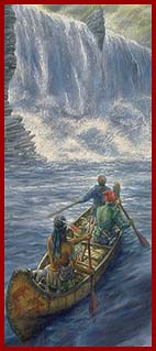
Champlain and his men in
front of Rideau Falls, 1613
Illustration by Francis Back
Collection of the Canadian Museum of Civilization
|
|
 (1613) Having then but two canoes, I was able to take with me
only four men, among whom was one named Nicolas de Vignau, the most impudent
liar that has been seen for a long time . . . (1613) Having then but two canoes, I was able to take with me
only four men, among whom was one named Nicolas de Vignau, the most impudent
liar that has been seen for a long time . . .
Accordingly, our canoes being laden with provisions, with our
arms, and with goods with which to make presents to the Indians, I set out
on Monday, May 27, from St. Helens island [Montreal] . . .
On the
fourth [of June] we passed near another river [Gatineau River] which comes
from the north where live tribes called Algonquins . . .
Near the
mouth of this river is another [Rideau River] coming from the south, and at
its mouth there is a wonderful waterfall . . .
|
. . .
Here are many small islands which are nothing more than rough, steep rocks
. . . At one place the water falls with such force upon a rock that with the
lapse of time it has hollowed out a wide, deep basin. Herein the water
whirls around to such an extent, and in the middle sends up such big swirls,
that the Indians call it Asticou, which means "boiler." This waterfall makes
such a noise in this basin that it can be heard for more than two leagues
away. The Indians who pass by this spot perform a ceremony . . .
Champlain, The Voyages, 1613
|
|
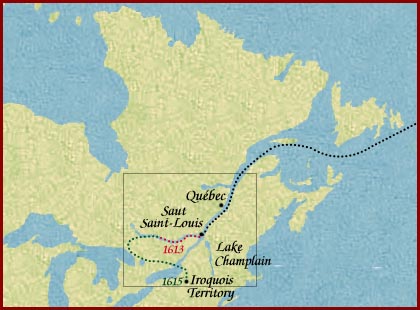
Champlains
journey west of the Ottawa River, 1613, 1615
Click in outlined area for a
detailed view
|
During his expedition, he identified the mouth of the Gatineau River
and Rideau Falls. When he arrived near the site where the Canadian Museum of
Civilization now stands, he was forced to portage to avoid the
Chaudière Falls.
According to Champlain, at that point, the water raged over the
rocks, digging a wide, deep basin. The Amerindians called the place Asticou,
meaning boiler, and before bypassing it, they made an offering of atonement.
Once past the obstacle, Champlain calculated the position of the site
using his astrolabe. The position he recorded in his journal was
45°38', but the Chaudière Falls are at 45°25'33". With his
small mariner's astrolabe, he could only estimate the position, with an
error of 15'.
To avoid the rapids at Gould's Landing, Champlain chose a course
through a number of small lakes near Cobden, Ontario, but this route was not
an easy one. He and his men were forced to portage over fallen logs at one
particularly difficult point by Green Lake, now known as Astrolabe Lake.
According to some late nineteenth-century authors, it was here that
Champlain lost his astrolabe.
|