Champlain, the Cartographer
Of all the "arts" he practised, Champlain valued none more than the
drawing of nautical charts using a mariners compass.
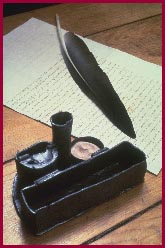
Inkstand, 17th
century
Found at the site of the second Quebec settlement
Ministère de la Culture et des Communications du
Québec,
Archaeological Collection
|
|
He [a seaman] should know how to make charts, so
as to be able to recognize accurately the lie of the coast, the entrances to
ports, the harbours, roadsteads, rocks, shoals, reefs, islands, anchorages,
capes, tide currents, inlets, rivers and streams . . .
Champlain, Treatise on Seamanship and the Duty of a good seaman, 1632
|
Champlain is best known for his scientific mind, as a keen observer
and a skilled technician. His talent for cartography, which he took up
during his first voyages, grew from his aptitude and experience as a
draughtsman.
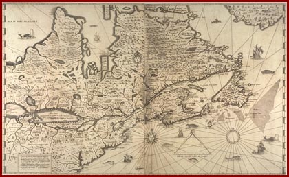
His Map of
1632
|
|
Map of New France . . .
made on its true meridian line by the Sieur de Champlain, Captain for the
King, 1632
Engraving
Champlain, The Voyages, 1632
Photo: National Archives of Canada
|
Champlains compatriots never considered him to be a writer. Marc
Lescarbot, a contemporary, grudgingly described Champlain as "an excellent
geographer."
In 1616, Champlain gave up exploring to concentrate on his work as
the viceroys lieutenant. While in this position, Champlain produced what is
now considered to be his best work. Champlains map of New France sums up
all his work, and is now deemed all the more important since he died shortly
after completing it.
The map shows North America from the northern regions to Virginia,
from Newfoundland to Lake Superior. It includes much of the information
Champlain gathered during his expeditions along the Ottawa River (1613), and
as far as lakes Nipissing and Huron (1615).
Champlains Maps
Description of the coasts, ports, roads and islands of New France
made in relation to its true meridian with the magnetic variation of several
places depending on whether the Sieur de Castes le franc [Castelfranc] shows
it in his book on compass calculations made and observed by the Sieur de
Champlain. 1607. Manuscript map showing Acadia from la Hève to
the south of Cape Cod, held by the Library of Congress in Washington, first
published by Biggar, portfolio, plate LXXX.
Geographic map of New France made by the Sieur de Champlain Saint
Tongois (Saintongeois) captain for the king and the navy.
Made in 1612. Published in the Voyages of 1613, reproduced in
Laverdière, Oeuvres, vol. III, p. 326 and in Biggar, portfolio,
plate LXXXI. Map of New France, from Newfoundland to the Great Lakes and
from lac Saint-Jean to Cape Cod, with the first mention of
Montréal, illustrated with specimens of the flora of Canada,
and Montagnais and Almouchiquois couples.
Geographic map of New France on its true meridian. Published
with the first print run of the Voyages of 1613. Reproduced in
Laverdière, Oeuvres, vol. III, p. 274 and in Biggar,
portfolio. Map showing the continent from Hudson Strait to Cape Cod, and
from Newfoundland to the Great Lakes, incorporating the information from the
English map of 1610 with no detail of the Ottawa River.
Geographic map of New France on its true meridian. Published
with the second print run of the Voyages of 1613. Reproduced in
Laverdière, Oeuvres, vol. III, p. 274 and in Biggar,
portfolio. Revised version of the previous map with an outline of the Ottawa
River.
Seventeen regional maps published in the Voyages of 1613. Reproduced in
Oeuvres (Laverdières edition), vol. III, and in Biggar,
vols. I and II:
Port de la Hève,
Port du Rossignol
Port au Mouton
Port des Mynes
Rivière St Jehan
Isle de Sainte Croix
Quinebequy [Kennebec] River
Chavacoit [Chouacouët] River
|
Port St Louis
Malle-Barre
Port-Royal
Le Beau-Port
Port-Fortuné
Tadoussac
Québec (2)
Le grand sault St Louis
|
General map published after Champlains death, no legend, [c. 1616].
Only copy (proof) acquired in 1953 by the John Carter Brown Library,
Providence, Rhode Island. Reproduced by the Champlain Society and published
in the edition of Biggars portfolio. This map adds to the maps of 1612 and
1613 the elements obtained during the war in Iroquoian territory and the
explorations carried out from the fall of 1615 to the spring of 1616. The
map was updated after Champlains death and published in 1653 by
cartographer Pierre du Val (Jean Glénisson, La France
dAmérique. Voyages de Samuel Champlain 1604-1629, Paris:
Imprimerie nationale, 1994, p. 362).
Map of New France, augmented since the last one, for use in
navigation, made on its true meridian by the Sieur de Champlain, kings
captain in the navy, who, from 1603 to 1629, discovered several coasts,
lands, lakes, rivers and nations of savages until then unknown, as can be
seen in the accounts he had published in 1632. This mark (IB)
indicates French settlements.. Published for the first time with the
Voyages of 1632, this map shows North America from Baffin Land to
Virginia and from Newfoundland to Lake Superior. Reproduced in
Laverdière, Oeuvres, vol. IV (at the end of the volume) and in
Biggars portfolio.
|