|
When the hostilities ceased in the eighteenth
century, French fishermen were confined to the French Shore.
 uropean fishermen had
shared the fishing grounds off Newfoundland since the sixteenth
century, but the situation had not always been peaceful. The War
of the Spanish Succession (1702-1713) and the Seven Years' War
(1756-1763) changed all the rules. uropean fishermen had
shared the fishing grounds off Newfoundland since the sixteenth
century, but the situation had not always been peaceful. The War
of the Spanish Succession (1702-1713) and the Seven Years' War
(1756-1763) changed all the rules.
In 1713, under the Treaty of Utrecht, France ceded Newfoundland
and Acadia to Britain in exchange for fishing rights on the island.
The first French Shore was thus established. The French had access
to the area extending from Cape Bonavista to Pointe Riche for the
seasonal fishery, but they were not allowed to settle. Fifty years
later, under the Treaty of Paris (1763), France gave up Canada but
clung desperately to its fishing rights in Newfoundland. In 1783 it
obtained a second French Shore, more limited in size, to the west,
extending from Cape Ray to Cape St. John.
|
|
Article 5 of the Treaty of Paris, signed on February
10, 1763, confirming Article 13 of the Treaty of Utrecht of 1713
Translation:
From now on, the island of Newfoundland and the adjacent islands will
belong exclusively to Great Britain... and from this day on, neither
the said most Christian king, his heirs and successors, nor any of his
subjects may make any claims at any time in relation to the said island
and the adjacent islands in whole or in part. They will also not be
allowed to fortify any place on the island or establish any type of
dwelling, with the exception of the usual stages and cabins needed for
drying fish, or land on the said island at any time other than that
which is customary and necessary for drying fish. The said subjects of
France will not be allowed to fish or dry fish on any part of the said
island other than that extending from the place called Cape Bonavista
to the north end of the said island, and from there along the western
side as far as the place called Pointe Riche...
|
|

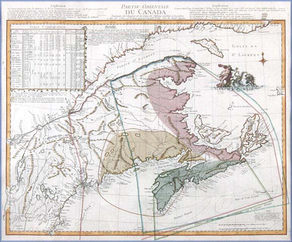
Eastern part of Canada... (detail), 1755
Map showing the boundaries of Acadia, which were being contested by
England and France on the eve of the Seven Years' War.
Engraved by Jeffreys and Le Rouge
(The James W. MacNutt Collection of Historic Maps, Prince Edward Island Museum
Number HF.96.1.13)
|
|
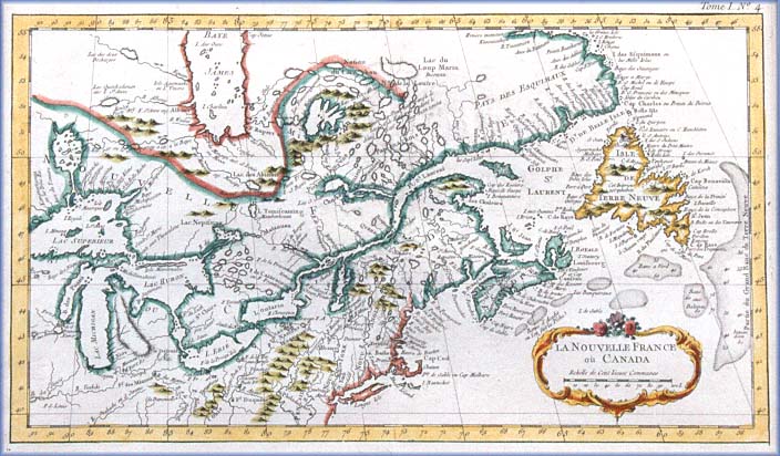
New France or Canada (detail), 1764
Map of the territories of New France and Canada just before the
Treaty of Paris was signed.
Engraved by Jacques Nicolas Bellin (1703-1772)
(The James W. MacNutt Collection of Historic Maps, Prince Edward Island Museum
Number HF.95.6.11)
|
|