The Last Best West: RETURN TO MAIN MENU


Advertising in the United States, 1900-1920s


National Library of Canada
 

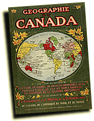
According to the title page, Géographie du Canada was written for schoolchildren and "colonists", in that order. In practice, a schoolchild often took an atlas home, where interested parents could read about opportunities available in western Canada. This method of promoting Canada had been well-tested in England.

Géographie du Canada was published in 1904 for distribution in the United States. The names and addresses of the Immigration Branch's resident agents appear on the inside cover of Geographie. Quebec-based "missionaires colonisateurs" are listed separately. Agents in France and Belgium were also listed.


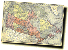
The atlas' map of Canada was printed in 1904, a year before the new provinces of Alberta and Saskatchewan were created - and seven years before the Manitoba/Ontario border was extended north to Hudson Bay.


National Library of Canada


The atlas' back cover presented Canada as a well-established democracy, with a fine Parliament Building in Ottawa and impressive provincial legislatures.


National Library of Canada


Back Next

The Early Years
1870-1897
Advertising in Britain
1900-1916
Advertising in Europe
1900-1920s
Presenting newcomers to Canada
1910-1911
Advertising in the United States
1900-1920s
Advertising in Britain
1920s
The Early Years, 1870-1897 Advertising in Britain, 1900-1916 Advertising in Europe, 1900-1920s Presenting newcomers to Canada, 1910-1911 Advertising in the United States, 1900-1920s Advertising in Britain, 1920s